


Super GeoGPS
คำอธิบายของSuper GeoGPS
This is the best tool for those working in surveying, mapping, construction, transportation, planning... It supports high precision GPS and Glonass navigation in fieldwork surveys.
This tool is designed for Civil Engineer, Surveyor, Civil Surveyor, Land Surveying and Topografia
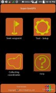
The typical functions of Super GeoGPS:
★ Super GeoGPS: Available many common reference systems, allows to set up more other reference systems.
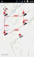
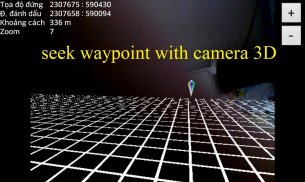
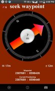
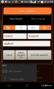
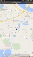
★ Super GeoGPS: Easy to finding waypoint on any reference coordinate systems by display direction, compass, distance, load Google maps. (for Civil Engineer and Surveyor)
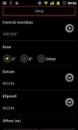
★ Super GeoGPS: Easy to use 7 transformations parameters in order to automatically convert between Geographic and UTM Coordinates. Synchronize Google map with UTM zone.
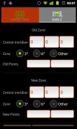
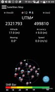
★ Super GeoGPS: Support convert between Geographic and UTM coordinates. Convert UTM coordinates between different zone.
★ Super GeoGPS: Measuring current waypoint high precision. Routing and automatically collect coordinates on the way by cycle preset then create a text file coordinates to easily attach to email or export to your computer.
★ Super GeoGPS: Avoid stray is tool will marking point along the way and shows direction to come back, It support those who take the survey in the forests and mountains, sea, or traveling.
★ Super GeoGPS: Support GPS and Glonass
- Geological Compass tool
- Management of waypoint file (multi waypoint file)
- Export waypoint file to excel or text file
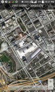
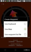
- Touch on Google map to add point
- Calculate the area (2D)
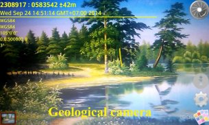
- Geological camera
- Compass adjustment
★ Super GeoGPS
- Fast config
- Add all of WGS84 central meridian.
- Tools for measuring distance between 2 devices
★ Super GeoGPS - Geodetic coordinates/UTM with:
- WGS1984
- WGS1972
- NAD1983/1927
- VN2000, HN1972
- Austria NS
- Belgium 50
- Nouv Trig de France 1
Super GeoGPS support 6 common language in the world (English, French, Chinese, Russia, Spanish and Vietnamese)
นี้เป็นเครื่องมือที่ดีที่สุดสำหรับผู้ที่ทำงานในการสำรวจทำแผนที่, การก่อสร้าง, การขนส่ง, การวางแผน ... มันสนับสนุนจีพีเอสที่มีความแม่นยำสูงและระบบนำทาง Glonass ในการสำรวจภาคสนาม
เครื่องมือนี้ถูกออกแบบมาสำหรับวิศวกรโยธา, กล้อง, โยธาสำรวจรังวัดที่ดินสำรวจและ Topografia
ฟังก์ชั่นตามแบบฉบับของซูเปอร์ GeoGPS:
★ GeoGPS ซูเปอร์: มีหลายระบบอ้างอิงทั่วไปจะช่วยให้การตั้งค่าระบบอ้างอิงอื่น ๆ
★ซูเปอร์ GeoGPS: ง่ายต่อการหา waypoint ในการอ้างอิงระบบพิกัดโดยทิศทางการแสดงผล, เข็มทิศ, ระยะทาง, โหลดแผนที่ Google (สำหรับวิศวกรโยธาและ Surveyor)
★ GeoGPS ซูเปอร์: ใช้ 7 แปลงพารามิเตอร์เพื่อแปลงโดยอัตโนมัติระหว่างทางภูมิศาสตร์และพิกัด UTM ง่าย ประสาน Google แผนที่กับโซน UTM
★ซูเปอร์ GeoGPS: การสนับสนุนการแปลงระหว่างทางภูมิศาสตร์และพิกัด UTM แปลงพิกัด UTM ระหว่างโซนที่แตกต่างกัน
★ซูเปอร์ GeoGPS: การวัดปัจจุบัน waypoint ความแม่นยำสูง การกำหนดเส้นทางและจะเก็บพิกัดบนทางโดยรอบที่ตั้งไว้แล้วสร้างไฟล์ข้อความพิกัดได้อย่างง่ายดายแนบไปกับอีเมลหรือส่งออกไปยังเครื่องคอมพิวเตอร์ของคุณ
★ GeoGPS ซูเปอร์: หลีกเลี่ยงจรจัดเป็นเครื่องมือที่จะทำเครื่องหมายจุดไปพร้อมกันและแสดงให้เห็นถึงทิศทางที่จะกลับมามันสนับสนุนผู้ที่ทำแบบสำรวจในป่าและภูเขาทะเลหรือเดินทาง
★ซูเปอร์ GeoGPS: จีพีเอสสนับสนุนและ Glonass
- เครื่องมือทางธรณีวิทยาเข็มทิศ
- การจัดการของไฟล์ waypoint (ไฟล์หลาย waypoint)
- ไฟล์ส่งออก waypoint จะเก่งหรือไฟล์ข้อความ
- สัมผัสบน Google Map เพื่อเพิ่มจุด
- คำนวณพื้นที่ (2D)
- กล้องทางธรณีวิทยา
- การปรับเข็มทิศ
★ซูเปอร์ GeoGPS
- การตั้งค่าได้อย่างรวดเร็ว
- เพิ่มทั้งหมดของ WGS84 กลางเส้นแวง
- เครื่องมือสำหรับการวัดระยะห่างระหว่าง 2 อุปกรณ์
★ GeoGPS เปอร์ - พิกัด Geodetic / UTM ด้วย:
- WGS1984
- WGS1972
- NAD1983 / 1927
- VN2000, HN1972
- ออสเตรีย NS
- เบลเยี่ยม 50
- Nouv หนุน de France 1
ซูเปอร์ GeoGPS สนับสนุน 6 ภาษาทั่วไปในโลก (อังกฤษ, ฝรั่งเศส, จีน, รัสเซีย, สเปนและเวียดนาม)
Super GeoGPS--เวอร์ชั่น6.0
(20-05-2020)Super GeoGPS - ข้อมูล APK
เวอร์ชั่น APK: 6.0แพ็คเกจ: com.truonghau.compassเวอร์ชั่นล่าสุดของSuper GeoGPS


 4.34
4.34

แอปในประเภทเดียวกัน

คุณอาจจะชอบ...


